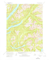
1955 Map of Ketchikan A-2
USGS Topo · Published 1976About this map
Boca De Quadra and its deep waterway of Marten Arm penetrate the southern reaches of the Tongass National Forest in this mid-century survey. The landscape is defined by the steep rises of the Peabody Mountains and a complex drainage system where the Marten River and Red River meet tidal waters. Human presence is sparse, marked primarily by industrial and subsistence sites such as an abandoned Fish Hatchery on the shores of Hugh Smith Lake and a lone Mine perched above the arm. Several Seaplane Landing Areas on Humpback Lake and Hugh Smith Lake emphasize the reliance on air travel for accessing these remote coastal watersheds. The map also traces smaller tributaries like Cobb Creek and Billy Goat Creek, alongside isolated structures like a Cabin near the coastline.
Find a feature on this map
24 named features on this map. Tap any name to fly to it.
Don’t see what you’re looking for? This feature index may not catch every label — zoom into the map to look around manually.
Map Details
Editions of this 1955 Ketchikan A-2 Map
3 editions found
Other maps of this area

1951 · Prince Rupert
USGS Topo · 1:250,000

1952 · Ketchikan
USGS Topo · 1:250,000

1955 · Ketchikan A-2
USGS Topo · 1:63,360

1955 · Prince Rupert D-3
USGS Topo · 1:63,360

1955 · Ketchikan A-1
USGS Topo · 1:63,360

1955 · Ketchikan B-2
USGS Topo · 1:63,360

1955 · Ketchikan B-1
USGS Topo · 1:63,360

1955 · Ketchikan A-3
USGS Topo · 1:63,360

1955 · Prince Rupert D-2
USGS Topo · 1:63,360

1955 · Ketchikan B-3
USGS Topo · 1:63,360