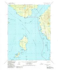
1955 Map of Ketchikan A-4
USGS Topo · Published 1984About this map
The maritime landscape of Southeast Alaska is defined here by the complex waterways surrounding Revillagigedo Island, where the Revillagigedo Channel meets the Behm Canal. Central to this 1955 survey is Mary Island, home to the Mary Island Lighthouse and Customhouse Cove, indicating its role in coastal navigation and border administration. The map highlights a transition in land management, showing the eastern portions within the Misty Fjords National Monument (Wilderness) and the broader Tongass National Forest. Scattered maritime outposts like Ham and Village I appear alongside family-named landmarks such as Walker I and Pt Winslow. The intricate shoreline, marked by hazardous reaches like Danger Passage, reflects the critical reliance on water travel before the era of modern road infrastructure in the Ketchikan Gateway Borough.
Find a feature on this map
55 named features on this map. Tap any name to fly to it.
Don’t see what you’re looking for? This feature index may not catch every label — zoom into the map to look around manually.
Map Details
Editions of this 1955 Ketchikan A-4 Map
3 editions found
Other maps of this area

1949 · Ketchikan B-4
USGS Topo · 1:63,360

1951 · Prince Rupert
USGS Topo · 1:250,000

1952 · Ketchikan
USGS Topo · 1:250,000

1952 · Ketchikan B-4
USGS Topo · 1:63,360

1954 · Ketchikan B-5
USGS Topo · 1:63,360

1955 · Prince Rupert D-3
USGS Topo · 1:63,360

1955 · Ketchikan A-4
USGS Topo · 1:63,360

1955 · Ketchikan A-5
USGS Topo · 1:63,360
1955 · Prince Rupert D-5
USGS Topo · 1:63,360
1955 · Prince Rupert D-4
USGS Topo · 1:63,360