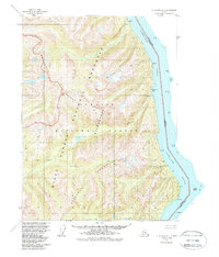
1955 Map of Ketchikan B-1
USGS Topo · Published 1988About this map
The United States Canada international boundary runs down the center of the Portland Canal in this mid-century topographic record of the Alaska panhandle. The terrain is dominated by the steep rises of the Rousseau Range, Monument Mountains, and Peabody Mountains, which together form a massive glaciated wall along the eastern edge of the Tongass National Forest. Within the Misty Fjords National Monument Wilderness, the landscape is defined by deep coastal incisions like Tombstone Bay and Halibut Bay. High alpine features such as Dome Peak overlook the Marten River drainage, while the shoreline of the canal is dotted with navigationally significant landmarks like Camp Point and the isolated Hattie Island. The lack of roads or settlements emphasizes the remote maritime character of this border region during the 1950s.
Find a feature on this map
24 named features on this map. Tap any name to fly to it.
Don’t see what you’re looking for? This feature index may not catch every label — zoom into the map to look around manually.
Map Details
Editions of this 1955 Ketchikan B-1 Map
3 editions found
Other maps of this area

1952 · Ketchikan
USGS Topo · 1:250,000

1955 · Ketchikan A-2
USGS Topo · 1:63,360

1955 · Ketchikan A-1
USGS Topo · 1:63,360

1955 · Ketchikan C-2
USGS Topo · 1:63,360

1955 · Ketchikan B-2
USGS Topo · 1:63,360

1955 · Ketchikan B-1
USGS Topo · 1:63,360

1955 · Ketchikan C-1
USGS Topo · 1:63,360

1955 · Ketchikan
USGS Topo · 1:250,000

1996 · Ketchikan C-2
USGS Topo · 1:63,360
2018 · Ketchikan B-1 NE
USGS Topo · 1:25,000