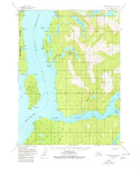
1955 Map of Ketchikan B-3
USGS Topo · Published 1980About this map
Behm Canal serves as the central artery of this 1955 survey, dividing the eastern edge of Revillagigedo Island from the mainland within the Tongass National Forest. The landscape is defined by the deep glacial troughs of Smeaton Bay, Wilson Arm, and Bakewell Arm, which penetrate far into the coastal mountains. This area, later protected as the Misty Fiords National Monument, shows a primitive wilderness state where the primary landmarks are named points and coves used for navigation, such as Pt Nelson and Pt Trollop.
Find a feature on this map
38 named features on this map. Tap any name to fly to it.
Don’t see what you’re looking for? This feature index may not catch every label — zoom into the map to look around manually.
Map Details
Editions of this 1955 Ketchikan B-3 Map
4 editions found

Other maps of this area

1949 · Ketchikan B-4
USGS Topo · 1:63,360

1952 · Ketchikan
USGS Topo · 1:250,000

1952 · Ketchikan B-4
USGS Topo · 1:63,360

1952 · Ketchikan C-4
USGS Topo · 1:63,360

1955 · Ketchikan A-2
USGS Topo · 1:63,360

1955 · Ketchikan C-3
USGS Topo · 1:63,360

1955 · Ketchikan C-2
USGS Topo · 1:63,360

1955 · Ketchikan A-4
USGS Topo · 1:63,360

1955 · Ketchikan B-2
USGS Topo · 1:63,360

1955 · Ketchikan A-3
USGS Topo · 1:63,360