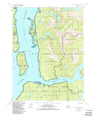
1955 Map of Ketchikan B-3
USGS Topo · Published 1988About this map
Behm Canal serves as the central waterway for this coastal Alaskan landscape, dividing the landmasses of Revillagigedo Island and the mainland. Based on 1955 field data with revisions through the late 1980s, the map illustrates the intricate drainage systems and glacial topography of the Tongass Nat For and the Misty Fjords Nat Mon. The isolation of the terrain is evident in the absence of developed roads, with coastal features like Wasp Cove and Checats Cove being the primary points of access. A chain of freshwater systems, including Lower Checats Lake and Upper Checats Lake, flows through the interior, while the deep inlets of Smeaton Bay and Wilson Arm penetrate the coast. Notable island features like Smeaton Island and Stag Island guard the entrance to protected passages, reflecting the complex marine geography of the Ketchikan Gateway Borough.
Find a feature on this map
38 named features on this map. Tap any name to fly to it.
Don’t see what you’re looking for? This feature index may not catch every label — zoom into the map to look around manually.
Map Details
Editions of this 1955 Ketchikan B-3 Map
4 editions found

Other maps of this area

1949 · Ketchikan B-4
USGS Topo · 1:63,360

1952 · Ketchikan
USGS Topo · 1:250,000

1952 · Ketchikan B-4
USGS Topo · 1:63,360

1952 · Ketchikan C-4
USGS Topo · 1:63,360

1955 · Ketchikan A-2
USGS Topo · 1:63,360

1955 · Ketchikan C-3
USGS Topo · 1:63,360

1955 · Ketchikan C-2
USGS Topo · 1:63,360

1955 · Ketchikan A-4
USGS Topo · 1:63,360

1955 · Ketchikan B-2
USGS Topo · 1:63,360

1955 · Ketchikan A-3
USGS Topo · 1:63,360