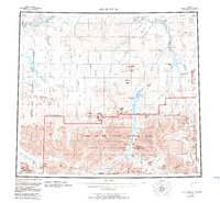
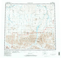
1956 Map of Killik River
USGS Topo · Published 1983About this map
The Brooks Range anchors the southern portion of this landscape, where the Gates Of The Arctic National Park protects a vast expanse of arctic wilderness. The survey reveals a complex hydrological network defined by the Killik River and the Colville River, which are fed by numerous seasonal creeks and glacial outwash. Notable landforms include the Itkilikruich Ridges and Pingatuligit Mountain, rising above the tundra plains.
Find a feature on this map
61 named features on this map. Tap any name to fly to it.
Don’t see what you’re looking for? This feature index may not catch every label — zoom into the map to look around manually.
Map Details
Editions of this 1956 Killik River Map
6 editions found

Other maps of this area

1951 · Lookout Ridge
USGS Topo · 1:250,000

1951 · Ikpikpuk River
USGS Topo · 1:250,000

1951 · Survey Pass
USGS Topo · 1:250,000

1951 · Chandler Lake
USGS Topo · 1:250,000

1951 · Howard Pass
USGS Topo · 1:250,000

1951 · Ambler River
USGS Topo · 1:250,000

1951 · Killik River
USGS Topo · 1:250,000

1951 · Wiseman
USGS Topo · 1:250,000

1952 · Umiat
USGS Topo · 1:250,000

1955 · Umiat A-5
USGS Topo · 1:63,360