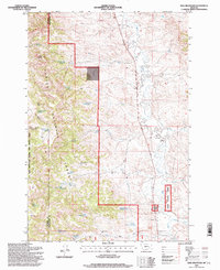
1995 Map of King Mountain
USGS Topo · Published 1998About this map
King Mountain dominates the western landscape of this 1990s-era survey, where the border between Rosebud and Powder River Counties runs through the heart of the Custer National Forest. The map captures a high-desert environment defined by complex water management, as evidenced by a series of stock ponds and basins including Newell Creek Reservoir, Chromo Reservoir, and Paget Reservoir No 1. These features, alongside named locations like Genie and Paget, illustrate the intersection of public forest land and the grazing infrastructure essential to this part of Montana.
Find a feature on this map
38 named features on this map. Tap any name to fly to it.
Don’t see what you’re looking for? This feature index may not catch every label — zoom into the map to look around manually.
Map Details
Editions of this 1995 King Mountain Map
This is the sole edition of this map. No revisions or reprints were ever made.
Other maps of this area

1954 · Hardin
USGS Topo · 1:250,000

1957 · Hardin
USGS Topo · 1:250,000

1958 · Hardin
USGS Topo · 1:250,000

1966 · Goodspeed Butte
USGS Topo · 1:24,000

1966 · Coleman Draw
USGS Topo · 1:24,000

1966 · Ashland
USGS Topo · 1:24,000

1966 · Poker Jim Butte
USGS Topo · 1:24,000

1966 · Fort Howes
USGS Topo · 1:24,000

1966 · King Mountain
USGS Topo · 1:24,000

1966 · Willow Crossing
USGS Topo · 1:24,000