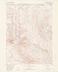
1950 Map of Kings Canyon
USGS Topo · Published 1969About this map
The Colorado State Boundary divides this high-altitude landscape where the Routt National Forest and Medicine Bow National Forest meet. This mid-century survey reveals a legacy of resource extraction, centered on the Village Belle Mine and Kings Canyon Mine. The Union Pacific line follows the northern contours, connecting several small outposts like Clayton and Camp Nelson. Settlement patterns appear tied to these industrial and transit hubs, with smaller locations such as Village and Camp established along the drainage of Camp Creek. The rugged terrain is defined by Pinkham Mountain and the unique geography of the North Sand Hills, while water management is evidenced by the Hardwork Ditch cutting through the hills near Kings Canyon Creek.
Find a feature on this map
32 named features on this map. Tap any name to fly to it.
Don’t see what you’re looking for? This feature index may not catch every label — zoom into the map to look around manually.
Map Details
Editions of this 1950 Kings Canyon Map
4 editions found
Other maps of this area

1906 · Medicine Bow
USGS Topo · 1:125,000

1908 · Medicine Bow
USGS Topo · 1:125,000

1950 · Northgate
USGS Topo · 1:24,000

1950 · Kings Canyon
USGS Topo · 1:24,000

1952 · Northgate
USGS Topo · 1:24,000

1952 · Kings Canyon
USGS Topo · 1:24,000

1954 · Rawlins
USGS Topo · 1:250,000

1954 · Craig
USGS Topo · 1:250,000

1955 · Old Roach
USGS Topo · 1:24,000

1955 · Eagle Hill
USGS Topo · 1:24,000