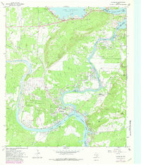
1967 Map of Kingsland
USGS Topo · Published 1982About this map
Kingsland occupies the scenic confluence of the Llano River and the Colorado River, a landscape dominated by the sprawling waters of Lake Lyndon B Johnson. This survey, updated with late-1970s land-use data, illustrates the mid-century development of the Texas Hill Country as a recreational and residential hub. The infrastructure of the Lower Colorado River Authority is prominent, from the massive Buchanan Dam at Lake Buchanan to the Inks Dam National Fish Hatchery near Inks Lake.
Find a feature on this map
53 named features on this map. Tap any name to fly to it.
Don’t see what you’re looking for? This feature index may not catch every label — zoom into the map to look around manually.
Map Details
Editions of this 1967 Kingsland Map
Other maps of this area

1887 · Llano
USGS Topo · 1:125,000

1887 · Burnet
USGS Topo · 1:125,000

1893 · Burnet
USGS Topo · 1:125,000

1894 · Llano
USGS Topo · 1:125,000

1903 · Burnet
USGS Topo · 1:125,000

1904 · Llano
USGS Topo · 1:125,000

1909 · Llano
USGS Topo · 1:125,000

1909 · Burnet
USGS Topo · 1:125,000

1918 · Llano
USGS Topo · 1:125,000

1925 · Burnet 3-b
USGS Topo · 1:48,000