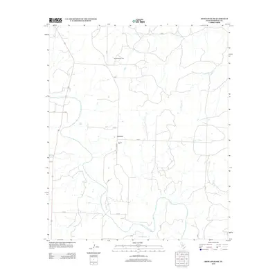
2012 Map of Kiowa Peak SW
USGS Topo · Published 2012About this map
Geneview is a central settlement point in this rural landscape, situated just north of the Mt Olive Cem. The terrain is shaped by the winding course of the Salt Fork Brazos River, which meanders through the western and southern portions of the quadrangle, joined by tributaries such as Stinking Cr and Wedington Cr. The presence of the Bissett Ranch Oil Field in the northern region highlights the intersection of agricultural ranching and the petroleum industry, a defining characteristic of this part of West Texas. A network of county roads, including C R 219 and C R 221, connects these disparate points of activity across the wide drainage basins.
Find a feature on this map
23 named features on this map. Tap any name to fly to it.
Don’t see what you’re looking for? This feature index may not catch every label — zoom into the map to look around manually.
Map Details
Editions of this 2012 Kiowa Peak SW Map
This is the sole edition of this map. No revisions or reprints were ever made.
Other maps of this area

1925 · Aspermont 4-a
USGS Topo · 1:48,000

1931 · Aspermont
USGS Topo · 1:62,500

1954 · Lubbock
USGS Topo · 1:250,000

1958 · Lovers Resort
USGS Topo · 1:24,000

1959 · Bob Creek
USGS Topo · 1:24,000

1962 · Kiowa Peak
USGS Topo · 1:24,000

1967 · Kiowa Peak NW
USGS Topo · 1:24,000

1967 · Kiowa Peak NE
USGS Topo · 1:24,000

1967 · Kiowa Peak SW
USGS Topo · 1:24,000
1968 · Aspermont
USGS Topo · 1:24,000