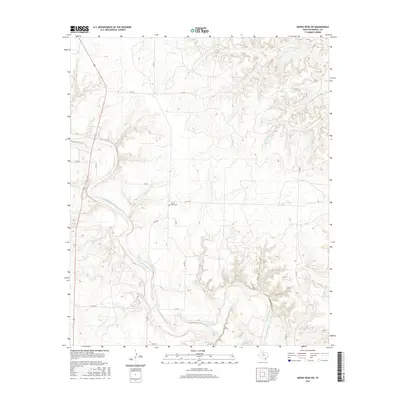
2016 Map of Kiowa Peak SW
USGS Topo · Published 2016About this map
The Salt Fork Brazos River carves a winding path through this portion of Stonewall County, creating a series of deep drainages and tributary breaks such as Stinking Cr and Wedington Cr. The landscape is largely defined by this riparian network, which dictates the layout of local ranch roads and cattle trails. One of the few established landmarks in this sparsely populated terrain is the Mount Olive Cem, situated near C R 219 and P-2170. Transportation in the area relies on a grid of county roads and the more prominent FM 1263, which intersects the northwest corner. This 2016 survey provides a precise view of the topography surrounding these watercourses, illustrating how the natural flow of the river continues to shape the infrastructure and agricultural use of the Texas plains.
Find a feature on this map
19 named features on this map. Tap any name to fly to it.
Don’t see what you’re looking for? This feature index may not catch every label — zoom into the map to look around manually.
Map Details
Editions of this 2016 Kiowa Peak SW Map
This is the sole edition of this map. No revisions or reprints were ever made.
Other maps of this area

1925 · Aspermont 4-a
USGS Topo · 1:48,000

1931 · Aspermont
USGS Topo · 1:62,500

1954 · Lubbock
USGS Topo · 1:250,000

1958 · Lovers Resort
USGS Topo · 1:24,000

1959 · Bob Creek
USGS Topo · 1:24,000

1962 · Kiowa Peak
USGS Topo · 1:24,000

1967 · Kiowa Peak NW
USGS Topo · 1:24,000

1967 · Kiowa Peak NE
USGS Topo · 1:24,000

1967 · Kiowa Peak SW
USGS Topo · 1:24,000
1968 · Aspermont
USGS Topo · 1:24,000