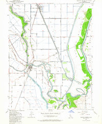
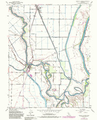
1952 Map of Knights Landing
USGS Topo · Published 1964About this map
Sacramento River meanders and oxbows define this central California landscape where the Southern Pacific railroad meets the water at Knights Landing. This mid-century survey illustrates an complex water management system essential to the region's agricultural life, featuring the Knights Landing Ridge Cut and the expansive Sutter By-Pass. The network of levees and canals, including the Colusa Basin Drainage Canal, protects low-lying areas while creating distinct water bodies like McGriff Lakes, Mary Lake, and Horseshoe Lake. The settlement of Robbins sits in the north, connected to the riverfront by a grid of rural roads such as Del Monte Ave and Riggins Road. Local civic life is anchored by the Knights Landing School and a nearby cemetery, while the industrial character of the era is marked by numerous pumping stations and the Fremont Weir.
Find a feature on this map
42 named features on this map. Tap any name to fly to it.
Don’t see what you’re looking for? This feature index may not catch every label — zoom into the map to look around manually.
Map Details
Editions of this 1952 Knights Landing Map
5 editions found
Other maps of this area

1907 · Dunnigan
USGS Topo · 1:62,500

1907 · Woodland
USGS Topo · 1:62,500

1907 · Davisville
USGS Topo · 1:62,500

1910 · Knights Landing
USGS Topo · 1:31,680

1910 · Vernon
USGS Topo · 1:31,680

1910 · Nicolaus
USGS Topo · 1:31,680

1910 · Marcuse
USGS Topo · 1:31,680

1915 · Yolo
USGS Topo · 1:31,680

1915 · Ronda
USGS Topo · 1:31,680
1915 · Kirkville
USGS Topo · 1:31,680