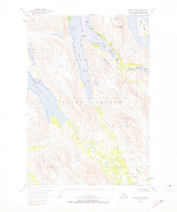
1952 Map of Kodiak C-5
USGS Topo · Published 1974About this map
Kodiak National Wildlife Refuge encompasses the entirety of this interior and coastal landscape, where the waters of Uganik Bay and Spiridon Bay reach deep into the mountainous heart of the island. The survey captures a complex network of glacial fjords and freshwater bodies, notably Uganik Lake and Spiridon Lake, connected by drainage systems like the Uganik River. The shoreline detail includes specific coastal features such as Packers Spit and Weasel Cove, providing essential data for those studying the island's maritime history and conservation boundaries.
Find a feature on this map
19 named features on this map. Tap any name to fly to it.
Don’t see what you’re looking for? This feature index may not catch every label — zoom into the map to look around manually.
Map Details
Editions of this 1952 Kodiak C-5 Map
3 editions found
Other maps of this area

1951 · Kodiak D-6
USGS Topo · 1:63,360

1952 · Kodiak
USGS Topo · 1:250,000

1952 · Kodiak B-6
USGS Topo · 1:63,360

1952 · Kodiak C-4
USGS Topo · 1:63,360

1952 · Kodiak C-5
USGS Topo · 1:63,360

1952 · Kodiak D-5
USGS Topo · 1:63,360

1952 · Kodiak B-5
USGS Topo · 1:63,360

1952 · Kodiak C-6
USGS Topo · 1:63,360

1952 · Kodiak D-4
USGS Topo · 1:63,360

1952 · Kodiak B-4
USGS Topo · 1:63,360