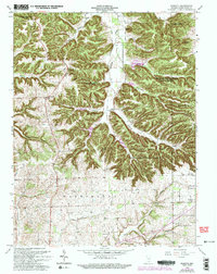
1963 Map of Kossuth
USGS Topo · Published 1994About this map
Jackson-Washington State Forest dominates the upper half of this landscape, where steep ridges and deep hollows define the topography between Monroe and Gibson townships. Small rural centers like Kossuth and Plattsburg anchor the road network, while the southern reaches of the map transition into the more level farming country of Washington and Franklin townships. The map records several legacy landmarks, including the Township Sch and multiple family-named burial sites such as Weston Cem and Winslow Cem. Drainage follows a complex pattern through Delaney Creek and the West Fork Blue River, illustrating the physical barriers that shaped early settlement patterns. This survey, revised in the early 1960s, provides an important record of southern Indiana's mid-century rural development before significant modern infrastructure changed the character of these small communities.
Find a feature on this map
31 named features on this map. Tap any name to fly to it.
Don’t see what you’re looking for? This feature index may not catch every label — zoom into the map to look around manually.
Map Details
Editions of this 1963 Kossuth Map
3 editions found
Other maps of this area

1950 · Salem
USGS Topo · 1:24,000

1950 · Becks Mill
USGS Topo · 1:24,000

1951 · Smedley
USGS Topo · 1:24,000

1953 · Kossuth
USGS Topo · 1:24,000

1955 · South Boston
USGS Topo · 1:24,000

1956 · Vincennes
USGS Topo · 1:250,000

1956 · Louisville
USGS Topo · 1:250,000

1957 · Vincennes
USGS Topo · 1:250,000

1958 · Vincennes
USGS Topo · 1:250,000

1958 · Little York
USGS Topo · 1:24,000