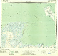
1951 Map of Kotzebue
USGS Topo · Published 1958About this map
Kotzebue sits at the tip of the Baldwin Peninsula, serving as a critical maritime and aviation hub for the Northwest Arctic region during the early fifties. This reconnaissance survey documents the vast aquatic and terrestrial systems where the Arctic Ocean meets the Kotzebue Sound. The landscape is defined by extensive river systems including the Nugnugaluktuk River and Goodhope River, which drain the lowlands of the Seward Peninsula. A significant landmark is Devil Mtn, rising above the coastal tundra and providing a rare point of elevation near the Arctic Circle.
Find a feature on this map
43 named features on this map. Tap any name to fly to it.
Don’t see what you’re looking for? This feature index may not catch every label — zoom into the map to look around manually.
Map Details
Editions of this 1951 Kotzebue Map
5 editions found

Other maps of this area

1950 · Kotzebue A-1
USGS Topo · 1:63,360

1950 · Kotzebue C-6
USGS Topo · 1:63,360

1950 · Bendeleben D-6
USGS Topo · 1:63,360

1950 · Bendeleben D-2
USGS Topo · 1:63,360

1950 · Teller
USGS Topo · 1:250,000

1950 · Bendeleben D-5
USGS Topo · 1:63,360

1950 · Bendeleben
USGS Topo · 1:250,000

1950 · Bendeleben D-3
USGS Topo · 1:63,360

1950 · Bendeleben D-1
USGS Topo · 1:63,360

1950 · Shishmaref
USGS Topo · 1:250,000