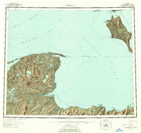
1951 Map of Kotzebue
USGS Topo · Published 1958About this map
Kotzebue serves as the focal point for this survey, situated on the Baldwin Peninsula at the meeting of Kotzebue Sound and Hotham Inlet. The map highlights the coastal geography of the Seward Peninsula and the remote reaches of the Arctic Circle as they appeared in the early 1950s. The landscape is defined by vast water networks, from the Noatak River Delta in the north to the Kugruk River in the south, near the settlement of Deering.
Find a feature on this map
49 named features on this map. Tap any name to fly to it.
Don’t see what you’re looking for? This feature index may not catch every label — zoom into the map to look around manually.
Map Details
Editions of this 1951 Kotzebue Map
5 editions found

Other maps of this area

1950 · Kotzebue A-1
USGS Topo · 1:63,360

1950 · Kotzebue C-6
USGS Topo · 1:63,360

1950 · Bendeleben D-6
USGS Topo · 1:63,360

1950 · Bendeleben D-2
USGS Topo · 1:63,360

1950 · Teller
USGS Topo · 1:250,000

1950 · Bendeleben D-5
USGS Topo · 1:63,360

1950 · Bendeleben
USGS Topo · 1:250,000

1950 · Bendeleben D-3
USGS Topo · 1:63,360

1950 · Bendeleben D-1
USGS Topo · 1:63,360

1950 · Shishmaref
USGS Topo · 1:250,000