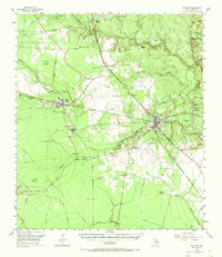
1955 Map of Kountze
USGS Topo · Published 1973About this map
Kountze serves as the focal point for this mid-century look at Hardin County, where the logging and petroleum industries shaped the local landscape. The map captures a transition in transportation, showing the Gulf Colorado and Santa Fe and the Texas and New Orleans (Southern Pacific) railroads alongside evidence of earlier timber operations like the Kirby Lumber Tram and an Old Railroad Grade. This industrial footprint is further evidenced by the East Village Mills Oil Field and the Nona Mills Oil Field, which punctuate the dense network of creeks.
Find a feature on this map
53 named features on this map. Tap any name to fly to it.
Don’t see what you’re looking for? This feature index may not catch every label — zoom into the map to look around manually.
Map Details
Editions of this 1955 Kountze Map
4 editions found
Other maps of this area

1932 · Beaumont
USGS Topo · 1:62,500

1943 · Liberty
USGS Topo · 1:125,000

1954 · Beaumont
USGS Topo · 1:250,000

1955 · Daisetta
USGS Topo · 1:62,500

1955 · Saratoga
USGS Topo · 1:62,500

1955 · Silsbee
USGS Topo · 1:62,500

1955 · Kountze
USGS Topo · 1:62,500

1955 · Sour Lake
USGS Topo · 1:62,500

1957 · Beaumont
USGS Topo · 1:250,000

1958 · Segno
USGS Topo · 1:62,500