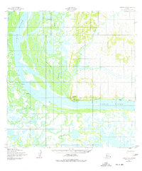
1952 Map of Kwiguk A-4
USGS Topo · Published 1977About this map
Mountain Village serves as a primary hub on this remote stretch of the Yukon River, situated beneath the prominent Azachorok Hill. In the early 1950s, this area supported essential transportation and communication infrastructure including a Seaplane Anchorage, a Landing Strip, and the Radio Station (KMTN). The landscape is defined by the intricate waterways of the Tunurokpak Channel, Patsys Slough, and Azacharum Slough, which weave through a series of small riverside settlements and seasonal outposts. Local history is recorded in names such as Johnnys Village, Kazhutak, and Mukialik, while a Winter Trail provides an overland link across the frozen delta terrain. Genealogists may find interest in the individual locations of Patsys Cabin and Cabins, along with the presence of Ruins and a Cem near the riverbanks.
Find a feature on this map
20 named features on this map. Tap any name to fly to it.
Don’t see what you’re looking for? This feature index may not catch every label — zoom into the map to look around manually.
Map Details
Editions of this 1952 Kwiguk A-4 Map
3 editions found
Other maps of this area

1951 · Marshall
USGS Topo · 1:250,000

1952 · Kwiguk
USGS Topo · 1:250,000

1952 · Kwiguk B-3
USGS Topo · 1:63,360

1952 · Kwiguk A-5
USGS Topo · 1:63,360

1952 · Kwiguk B-5
USGS Topo · 1:63,360

1952 · Kwiguk A-4
USGS Topo · 1:63,360

1952 · Kwiguk A-3
USGS Topo · 1:63,360

1952 · Kwiguk B-4
USGS Topo · 1:63,360

1952 · Marshall D-5
USGS Topo · 1:63,360

1952 · Marshall D-4
USGS Topo · 1:63,360