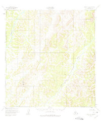
1952 Map of Kwiguk C-1
USGS Topo · Published 1975About this map
The Andreafsky River corridor dominates this 1952 topographic study, showcasing a remote Alaskan landscape defined by its intricate drainage patterns. The river flows along the western edge of the quadrangle, while the East Fork Andreafsky River snakes through the central and southern reaches. Rising above the surrounding terrain in the southwest, North Peak provides a primary point of elevation for navigators and surveyors. Compiled from aerial photography taken in 1951 and field-annotated in 1952, the map documents an unsurveyed wilderness under the jurisdiction of the Bureau of Land Management before modern infrastructure reached this part of the Seward Meridian.
Find a feature on this map
3 named features on this map. Tap any name to fly to it.
Don’t see what you’re looking for? This feature index may not catch every label — zoom into the map to look around manually.
Map Details
Editions of this 1952 Kwiguk C-1 Map
4 editions found
Other maps of this area

1951 · Holy Cross
USGS Topo · 1:250,000

1952 · Kwiguk
USGS Topo · 1:250,000

1952 · Kwiguk D-1
USGS Topo · 1:63,360

1952 · Kwiguk B-2
USGS Topo · 1:63,360

1952 · Kwiguk C-2
USGS Topo · 1:63,360

1952 · Kwiguk D-2
USGS Topo · 1:63,360

1952 · Holy Cross C-6
USGS Topo · 1:63,360

1952 · Holy Cross B-6
USGS Topo · 1:63,360

1952 · Kwiguk B-1
USGS Topo · 1:63,360

1952 · Kwiguk C-1
USGS Topo · 1:63,360