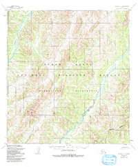
1952 Map of Kwiguk C-1
USGS Topo · Published 1991About this map
Andreafsky River and its major tributary, the East Fork Andreafsky River, dominate this Alaskan landscape within the Yukon Delta National Wildlife Refuge. The map reflects a mid-century period of federal conservation and mapping, based on 1951 aerial photography and 1952 field annotations. The terrain is defined by complex contouring and prominent landmarks like North Peak, illustrating the untouched wilderness character of the region. The boundary of the Andreafsky Wilderness is clearly delineated, marking a territory where the natural hydrography of the river system remains the primary feature. This study serves as a baseline for understanding the protected lands of the Yukon Delta before later environmental shifts and administrative revisions.
Find a feature on this map
6 named features on this map. Tap any name to fly to it.
Don’t see what you’re looking for? This feature index may not catch every label — zoom into the map to look around manually.
Map Details
Editions of this 1952 Kwiguk C-1 Map
4 editions found
Other maps of this area

1951 · Holy Cross
USGS Topo · 1:250,000

1952 · Kwiguk
USGS Topo · 1:250,000

1952 · Kwiguk D-1
USGS Topo · 1:63,360

1952 · Kwiguk B-2
USGS Topo · 1:63,360

1952 · Kwiguk C-2
USGS Topo · 1:63,360

1952 · Kwiguk D-2
USGS Topo · 1:63,360

1952 · Holy Cross C-6
USGS Topo · 1:63,360

1952 · Holy Cross B-6
USGS Topo · 1:63,360

1952 · Kwiguk B-1
USGS Topo · 1:63,360

1952 · Kwiguk C-1
USGS Topo · 1:63,360