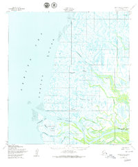
1952 Map of Kwiguk D-6
USGS Topo · Published 1979About this map
The labyrinthine distributaries of the Yukon Delta meet Norton Sound in this mid-century survey. The settlement of Emmonak is situated along the Emmonak Slough, accompanied by a nearby Landing Strip that indicates the critical role of bush aviation in this roadless region. To the south, the former location of Kwiguk (Site) is noted near the mouth of the massive Kwiguk Pass. The landscape is dominated by a complex network of tidal channels and islands, including Kawokhawik Island and Kangokakli, separated by smaller waterways like Akanuklinuk Slough and Elukozuk Slough. This environment, characterized by shifting silt and mud flats along the Bering Sea, reflects the dynamic nature of the delta before later twentieth-century developments altered the local geography.
Find a feature on this map
20 named features on this map. Tap any name to fly to it.
Don’t see what you’re looking for? This feature index may not catch every label — zoom into the map to look around manually.
Map Details
Editions of this 1952 Kwiguk D-6 Map
2 editions found
Other maps of this area

1951 · Black
USGS Topo · 1:250,000

1951 · St Michael
USGS Topo · 1:250,000

1952 · Kwiguk
USGS Topo · 1:250,000
1952 · Black C-1
USGS Topo · 1:63,360

1952 · Saint Michael A-5
USGS Topo · 1:63,360
1952 · Saint Michael A-6
USGS Topo · 1:63,360

1952 · Kwiguk C-6
USGS Topo · 1:63,360

1952 · Kwiguk D-6
USGS Topo · 1:63,360

1952 · Kwiguk C-5
USGS Topo · 1:63,360

1952 · Kwiguk D-5
USGS Topo · 1:63,360