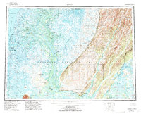
1952 Map of Kwiguk
USGS Topo · Published 1994About this map
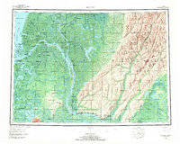
The Yukon River branches into a complex network of waterways as it approaches the Bering Sea, creating the tidal landscape of the Yukon Delta National Wildlife Refuge. This 1952 survey documents numerous riverine settlements and seasonal camps that define the region's geography, such as Kwiguk, Emmonak, and Alakanuk. The interior is marked by the Head of Passes, where the main channel divides into the Kwikpak Pass, Kwikluak Pass, and Kwemeluk Pass. Along the eastern edge, the terrain rises sharply from the delta marshes into the Andreafsky Hills and the Andreafsky Wilderness. Evidence of local infrastructure is noted through the Winter Trail, a Landing Strip, and a Seaplane Anchorage, while the location of Andreafsky (St Marys PO) and Old Andreafsky near the confluence of the Andreafsky River highlights the historical importance of these inland junctions.
Find a feature on this map
70 named features on this map. Tap any name to fly to it.
Don’t see what you’re looking for? This feature index may not catch every label — zoom into the map to look around manually.
Map Details
Editions of this 1952 Kwiguk Map
8 editions found
Other maps of this area

1947 · Russian Mission
USGS Topo · 1:250,000

1950 · Russian Mission
USGS Topo · 1:250,000

1951 · Marshall
USGS Topo · 1:250,000

1951 · Unalakleet
USGS Topo · 1:250,000

1951 · Hooper Bay
USGS Topo · 1:250,000

1951 · Black
USGS Topo · 1:250,000

1951 · St Michael
USGS Topo · 1:250,000

1951 · Holy Cross
USGS Topo · 1:250,000

1952 · Kwiguk
USGS Topo · 1:250,000

1952 · Kwiguk D-1
USGS Topo · 1:63,360