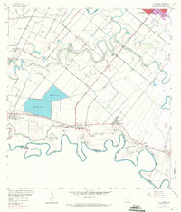
1956 Map of La Paloma
USGS Topo · Published 1971About this map
Meandering loops of the Rio Grande define the international boundary between Texas and Mexico in this mid-century portrait of Cameron County. The landscape is dominated by a complex network of irrigation ditches and ancient river channels known as resacas, including Resaca De Los Fresnos and Resaca Del Rancho Viejo. Large-scale water management is evidenced by Reservoir No 1 and Reservoir No 2, essential for the agricultural settlements that dot the region.
Find a feature on this map
41 named features on this map. Tap any name to fly to it.
Don’t see what you’re looking for? This feature index may not catch every label — zoom into the map to look around manually.
Map Details
Editions of this 1956 La Paloma Map
3 editions found
Other maps of this area

1929 · Rio Hondo
USGS Topo · 1:24,000

1929 · Harlingen
USGS Topo · 1:24,000

1929 · Santa Maria
USGS Topo · 1:24,000

1929 · La Feria
USGS Topo · 1:24,000

1929 · La Paloma
USGS Topo · 1:24,000

1930 · West Brownsville
USGS Topo · 1:24,000

1930 · Barreda
USGS Topo · 1:24,000

1932 · Rio Hondo
USGS Topo · 1:31,680

1932 · Harlingen
USGS Topo · 1:31,680

1936 · La Feria
USGS Topo · 1:31,680