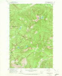
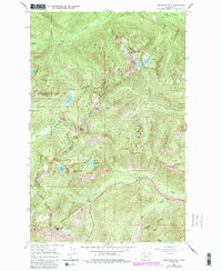
1965 Map of Labyrinth Mtn
USGS Topo · Published 1972About this map
The Great Northern Tunnel pierces the high divide near the southern edge of this mid-1960s survey, marking a vital transit corridor through the Cascades. This rugged landscape at the junction of the Wenatchee National Forest and Snoqualmie National Forest is defined by sharp peaks like Labyrinth Mtn and Lichtenberg Mtn. The Cascade Crest Trail winds across the high ridges, connecting alpine water bodies such as Lake Janus and Valhalla Lake. Near the southeastern corner, the early infrastructure of the Stevens Pass 4 Lane and a nearby ski lift suggest the region's mid-century development as a recreational destination. The map also records numerous pack trails and isolated landmarks like a Shelter and Radio Tower, documenting the balance between industrial rail engineering and remote mountain wilderness.
Find a feature on this map
38 named features on this map. Tap any name to fly to it.
Don’t see what you’re looking for? This feature index may not catch every label — zoom into the map to look around manually.
Map Details
Editions of this 1965 Labyrinth Mtn Map
5 editions found
Other maps of this area

1901 · Chiwaukum
USGS Topo · 1:125,000

1902 · Skykomish
USGS Topo · 1:125,000

1904 · Chiwaukum
USGS Topo · 1:125,000

1905 · Skykomish
USGS Topo · 1:125,000

1957 · Wenatchee
USGS Topo · 1:250,000

1965 · Captain Point
USGS Topo · 1:24,000

1965 · Chiwaukum Mts
USGS Topo · 1:62,500

1965 · Stevens Pass
USGS Topo · 1:24,000

1965 · Wenatchee Lake
USGS Topo · 1:62,500

1965 · Poe Mountain
USGS Topo · 1:24,000