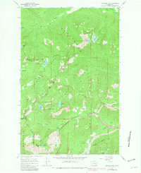
1965 Map of Labyrinth Mtn
USGS Topo · Published 1981About this map
Stevens Pass serves as the focal point for this high-altitude survey of the North Cascades, documenting the critical transport corridor at the meeting of Wenatchee National Forest and Snoqualmie National Forest. The map captures the infrastructure of the era, showing the Burlington Northern Tunnel cutting through the mountain depths while the Old Cascade Highway and a Ski Lift mark the development of recreation and transit. The landscape is defined by its numerous alpine basins, including Minotaur Lake and Theseus Lake beneath Labyrinth Mtn. These remote waters, along with Lake Janus and Valhalla Lake, are connected by the Cascade Crest Trail, which follows the high ridges and county lines. A Gravel Pit and Radio Tower indicate small pockets of industrial activity amidst the summits of Lichtenberg Mtn and Jove Peak.
Find a feature on this map
38 named features on this map. Tap any name to fly to it.
Don’t see what you’re looking for? This feature index may not catch every label — zoom into the map to look around manually.
Map Details
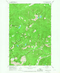
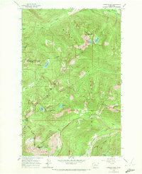
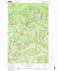
Editions of this 1965 Labyrinth Mtn Map
5 editions found
Historical Maps of King County Through Time
169 maps found

1901 Chiwaukum
Chelan County, WA

1902 Stehekin
Chelan County, WA

1904 Chiwaukum
Chelan County, WA

1904 Stehekin
Chelan County, WA

1944 Holden
Chelan County, WA

1944 Lucerne
Chelan County, WA

1949 Holden
Chelan County, WA

1949 Lucerne
Chelan County, WA

1961 Liberty
Chelan County, WA

1963 Agnes Mtn.
Chelan County, WA

1963 Goode Mtn
Chelan County, WA

1963 Mc Gregor Mtn
Chelan County, WA

1963 Mt Lyall
Chelan County, WA

1965 Chiwaukum Mts
Chelan County, WA

1965 Labyrinth Mtn
Chelan County, WA

1965 Poe Mountain
Chelan County, WA

1965 Stevens Pass
Chelan County, WA

1965 The Cradle
Chelan County, WA

1965 Wenatchee Lake
Chelan County, WA

1966 Malaga
Chelan County, WA

1966 Mission Peak
Chelan County, WA

1966 Monitor
Chelan County, WA

1966 Wenatchee Heights
Chelan County, WA

1968 Ardenvoir
Chelan County, WA

1968 Azwell
Chelan County, WA

1968 Baldy Mountain
Chelan County, WA

1968 Big Goat Mtn
Chelan County, WA

1968 Brief
Chelan County, WA

1968 Chikamin Creek
Chelan County, WA

1968 Chumstick Mtn
Chelan County, WA

1968 Cooper Ridge
Chelan County, WA

1968 Oss Peak
Chelan County, WA

1968 Plain
Chelan County, WA

1968 Rocky Reach Dam
Chelan County, WA

1968 Silver Falls
Chelan County, WA

1968 South Navarre Peak
Chelan County, WA

1968 Stormy Mtn.
Chelan County, WA

1968 Sugarloaf Peak
Chelan County, WA

1968 Tyee Mtn.
Chelan County, WA

1968 Winesap
Chelan County, WA

1969 Mc Alester Mtn
Chelan County, WA

1969 Prince Creek
Chelan County, WA

1969 Stehekin
Chelan County, WA

1969 Sun Mountain
Chelan County, WA

1988 Clark Mountain
Chelan County, WA

1988 Holden
Chelan County, WA

1988 Lucerne
Chelan County, WA

1988 Pinnacle Mountain
Chelan County, WA

1988 Pyramid Mountain
Chelan County, WA

1988 Saska Peak
Chelan County, WA

1988 Suiattle Pass
Chelan County, WA

1988 Trinity
Chelan County, WA

1989 Big Jim Mountain
Chelan County, WA

1989 Blewett
Chelan County, WA

1989 Cashmere Mountain
Chelan County, WA

1989 Chiwaukum Mountains
Chelan County, WA

1989 Enchantment Lakes
Chelan County, WA

1989 Jack Ridge
Chelan County, WA

1989 Lake Wenatchee
Chelan County, WA

1989 Mount David
Chelan County, WA

1989 Mount Howard
Chelan County, WA

1989 Peshastin
Chelan County, WA

1989 Schaffer Lake
Chelan County, WA

1989 Tiptop
Chelan County, WA

1989 Van Creek
Chelan County, WA

1989 Winton
Chelan County, WA

1999 Suiattle Pass
Chelan County, WA

2001 Azwell
Chelan County, WA

2002 McAlester Mountain
Chelan County, WA

2002 Sun Mountain
Chelan County, WA

2003 Ardenvoir
Chelan County, WA

2003 Blewett
Chelan County, WA

2003 Cashmere Mountain
Chelan County, WA

2003 Chumstick Mountain
Chelan County, WA

2003 Enchantment Lakes
Chelan County, WA

2003 Jack Ridge
Chelan County, WA

2003 Mission Peak
Chelan County, WA

2003 Monitor
Chelan County, WA

2003 Peshastin
Chelan County, WA

2003 Rocky Reach Dam
Chelan County, WA

2003 The Cradle
Chelan County, WA

2003 Tiptop
Chelan County, WA

2003 Van Creek
Chelan County, WA

2003 Wenatchee Heights
Chelan County, WA

2003 Winton
Chelan County, WA

2004 Baldy Mountain
Chelan County, WA

2004 Brief
Chelan County, WA

2004 Chikamin Creek
Chelan County, WA

2004 Chiwaukum Mountains
Chelan County, WA

2004 Clark Mountain
Chelan County, WA

2004 Cooper Ridge
Chelan County, WA

2004 Goode Mountain
Chelan County, WA

2004 Holden
Chelan County, WA

2004 Lake Wenatchee
Chelan County, WA

2004 Lucerne
Chelan County, WA

2004 McGregor Mountain
Chelan County, WA

2004 Mount David
Chelan County, WA

2004 Mount Howard
Chelan County, WA

2004 Mount Lyall
Chelan County, WA

2004 Oss Peak
Chelan County, WA

2004 Pinnacle Mountain
Chelan County, WA

2004 Plain
Chelan County, WA

2004 Poe Mountain
Chelan County, WA

2004 Prince Creek
Chelan County, WA

2004 Pyramid Mountain
Chelan County, WA

2004 Saska Peak
Chelan County, WA

2004 Schaffer Lake
Chelan County, WA

2004 Silver Falls
Chelan County, WA

2004 South Navarre Peak
Chelan County, WA

2004 Stormy Mountain
Chelan County, WA

2004 Sugarloaf Peak
Chelan County, WA

2004 Tyee Mountain
Chelan County, WA

2004 Winesap
Chelan County, WA

2005 Big Jim Mountain
Chelan County, WA

2023 Agnes Mountain
Chelan County, WA

2023 Ardenvoir
Chelan County, WA

2023 Azwell
Chelan County, WA

2023 Baldy Mountain
Chelan County, WA

2023 Big Goat Mountain
Chelan County, WA

2023 Big Jim Mountain
Chelan County, WA

2023 Blewett
Chelan County, WA

2023 Brief
Chelan County, WA

2023 Cashmere Mountain
Chelan County, WA

2023 Chikamin Creek
Chelan County, WA

2023 Chiwaukum Mountains
Chelan County, WA

2023 Chumstick Mountain
Chelan County, WA

2023 Clark Mountain
Chelan County, WA

2023 Cooper Ridge
Chelan County, WA

2023 Enchantment Lakes
Chelan County, WA

2023 Goode Mountain
Chelan County, WA

2023 Holden
Chelan County, WA

2023 Jack Ridge
Chelan County, WA

2023 Labyrinth Mountain
Chelan County, WA

2023 Lake Wenatchee
Chelan County, WA

2023 Lucerne
Chelan County, WA

2023 Malaga
Chelan County, WA

2023 McAlester Mountain
Chelan County, WA

2023 McGregor Mountain
Chelan County, WA

2023 Mission Peak
Chelan County, WA

2023 Monitor
Chelan County, WA

2023 Mount David
Chelan County, WA

2023 Mount Howard
Chelan County, WA

2023 Mount Lyall
Chelan County, WA

2023 Oss Peak
Chelan County, WA

2023 Peshastin
Chelan County, WA

2023 Pinnacle Mountain
Chelan County, WA

2023 Plain
Chelan County, WA

2023 Poe Mountain
Chelan County, WA

2023 Prince Creek
Chelan County, WA

2023 Pyramid Mountain
Chelan County, WA

2023 Rocky Reach Dam
Chelan County, WA

2023 Saska Peak
Chelan County, WA

2023 Schaefer Lake
Chelan County, WA

2023 Silver Falls
Chelan County, WA

2023 South Navarre Peak
Chelan County, WA

2023 Stehekin
Chelan County, WA

2023 Stevens Pass
Chelan County, WA

2023 Stormy Mountain
Chelan County, WA

2023 Sugarloaf Peak
Chelan County, WA

2023 Suiattle Pass
Chelan County, WA

2023 Sun Mountain
Chelan County, WA

2023 The Cradle
Chelan County, WA

2023 Tiptop
Chelan County, WA

2023 Trinity
Chelan County, WA

2023 Tyee Mountain
Chelan County, WA

2023 Van Creek
Chelan County, WA

2023 Wenatchee Heights
Chelan County, WA

2023 Winesap
Chelan County, WA

2023 Winton
Chelan County, WA