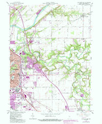
1961 Map of Lafayette East
USGS Topo · Published 1987About this map
Wildcat Creek and its many branches, including the Middle Fork Wildcat Creek and the South Fork Wildcat Creek, wind through this landscape as the city of Lafayette expands eastward. The 1960s suburban growth is captured in the development of neighborhoods like Eastwitch and Meadowbrook, while older community anchors like the Longlois Sch and St Boniface Cemetery remain. The map documents a period of significant transportation infrastructure, showing the Norfolk and Western and CSX rail lines alongside newly established interstate interchanges. Local aviation history is preserved through the presence of Aretz Airport to the north and Halsmer Airport to the south, while leisure sites like the Drive-in Theater and Columbian Park reflect the mid-century recreation of the Tippecanoe County seat.
Find a feature on this map
58 named features on this map. Tap any name to fly to it.
Don’t see what you’re looking for? This feature index may not catch every label — zoom into the map to look around manually.
Map Details
Editions of this 1961 Lafayette East Map
5 editions found

Other maps of this area

1941 · Lafayette
USGS Topo · 1:24,000

1942 · Lafayette
USGS Topo · 1:24,000

1950 · Lafayette
USGS Topo · 1:24,000

1953 · Danville
USGS Topo · 1:250,000

1955 · Danville
USGS Topo · 1:250,000

1956 · Danville
USGS Topo · 1:250,000

1961 · Mulberry
USGS Topo · 1:24,000

1961 · Pyrmont
USGS Topo · 1:24,000

1961 · Romney
USGS Topo · 1:24,000

1961 · Stockwell
USGS Topo · 1:24,000