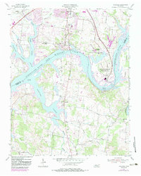
1955 Map of Laguardo
USGS Topo · Published 1983About this map
Old Hickory Lake dominates this mid-century landscape, illustrating the transformative impact of the TVA on the border of Sumner and Wilson counties. The Gallatin Steam Plant Reservation and its associated conveyor systems signal the industrial modernization of the Tennessee river valley, while older community hubs like Laguardo and Cedar Grove persist along the winding shorelines.
Find a feature on this map
44 named features on this map. Tap any name to fly to it.
Don’t see what you’re looking for? This feature index may not catch every label — zoom into the map to look around manually.
Map Details
Editions of this 1955 Laguardo Map
5 editions found

Other maps of this area

1903 · Nashville
USGS Topo · 1:125,000

1932 · Hermitage
USGS Topo · 1:62,500

1942 · Gallatin
USGS Topo · 1:100,000

1942 · Lebanon
USGS Topo · 1:100,000

1951 · Lebanon
USGS Topo · 1:24,000

1951 · Martha
USGS Topo · 1:24,000

1952 · Hendersonville
USGS Topo · 1:24,000

1952 · Hermitage
USGS Topo · 1:24,000

1953 · Cottontown
USGS Topo · 1:24,000

1955 · Bethpage
USGS Topo · 1:24,000