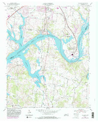
1955 Map of Laguardo
USGS Topo · Published 1983About this map
Old Hickory Lake and the meandering Cumberland River dominate this landscape on the border of Sumner and Wilson Counties. The map illustrates a transitional period in Middle Tennessee's development, where rural crossroads like Laguardo and older social hubs such as Franklin Chapel and Cooks Church sit alongside the industrial modernization of the Gallatin Steam Plant Reservation (TVA). The 1980s photorevisions show the expansion of the Gallatin suburbs and the development of recreational spaces like Sumner County Park, while still preserving the traces of older infrastructure such as the Seaboard rail line and the historic Coles Ferry Road. Significant water features including Spencer Creek and Station Camp Creek branch into the reservoir, defining the local topography and the boundaries of residential growth near the Gallatin Municipal Airport.
Find a feature on this map
42 named features on this map. Tap any name to fly to it.
Don’t see what you’re looking for? This feature index may not catch every label — zoom into the map to look around manually.
Map Details
Editions of this 1955 Laguardo Map
5 editions found

Other maps of this area

1903 · Nashville
USGS Topo · 1:125,000

1932 · Hermitage
USGS Topo · 1:62,500

1942 · Gallatin
USGS Topo · 1:100,000

1942 · Lebanon
USGS Topo · 1:100,000

1951 · Lebanon
USGS Topo · 1:24,000

1951 · Martha
USGS Topo · 1:24,000

1952 · Hendersonville
USGS Topo · 1:24,000

1952 · Hermitage
USGS Topo · 1:24,000

1953 · Cottontown
USGS Topo · 1:24,000

1955 · Bethpage
USGS Topo · 1:24,000