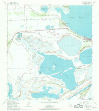
1955 Map of Laguna Vista
USGS Topo · Published 1971About this map
The coastal landscape of the Lower Rio Grande Valley unfolds across this 1955 survey, showcasing a complex network of bays, ridges, and emergent developments. Laguna Vista and Laguna Heights appear as established settlements along the western edge of the Laguna Madre, positioned near the historic Old Railroad Grade. This transport corridor, while no longer an active rail line, still serves as a defining boundary between the inland lomas and the sprawling waters of Laguna Larga. To the south, the deep Ship Channel cuts through the marshy terrain toward the Boca Chica Passing Basin, signaling the area's maritime importance.
Find a feature on this map
34 named features on this map. Tap any name to fly to it.
Don’t see what you’re looking for? This feature index may not catch every label — zoom into the map to look around manually.
Map Details
Editions of this 1955 Laguna Vista Map
4 editions found
Other maps of this area

1929 · La Coma
USGS Topo · 1:24,000

1929 · Palmito Hill
USGS Topo · 1:24,000

1929 · Point Isabel
USGS Topo · 1:24,000

1929 · Laguna Vista
USGS Topo · 1:24,000

1930 · Padre Island No. 1
USGS Topo · 1:24,000

1930 · Los Fresnos
USGS Topo · 1:24,000

1930 · Laguna Atascosa
USGS Topo · 1:24,000

1930 · East Brownsville
USGS Topo · 1:24,000

1934 · Port Isabel
USGS Topo · 1:31,680

1934 · La Coma
USGS Topo · 1:31,680