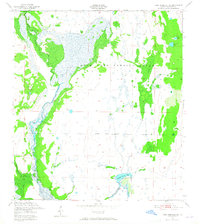
1952 Map of Lake Arbuckle SE
USGS Topo · Published 1965About this map
Avon Park Bombing Range dominates this mid-century Florida landscape, revealing a vast military installation characterized by its distinctive wetland and glade terrain. The map depicts a complex hydrologic network defined by Arbuckle Creek as it winds through the western portion of the quadrangle. Interior features like Morgan Glade and Long Cypress Slash illustrate the seasonal water patterns and vegetation common to this part of Highlands County before significant modern development. The presence of specialized features such as Submarine Lake and Little Lake within the range suggests military utility or training areas, while the Bombing Range Boundary clearly delineates the military zone from the surrounding area near Bonny Bloom Pond and Wildcat Branch.
Find a feature on this map
14 named features on this map. Tap any name to fly to it.
Don’t see what you’re looking for? This feature index may not catch every label — zoom into the map to look around manually.
Map Details
Editions of this 1952 Lake Arbuckle SE Map
4 editions found
Other maps of this area

1952 · Fort Kissimmee
USGS Topo · 1:24,000

1952 · Lake Arbuckle SW
USGS Topo · 1:24,000

1952 · Fort Kissimmee NW
USGS Topo · 1:24,000

1952 · Lake Arbuckle NE
USGS Topo · 1:24,000

1952 · Lake Arbuckle SE
USGS Topo · 1:24,000

1952 · Lake Arbuckle
USGS Topo · 1:24,000

1952 · Lorida
USGS Topo · 1:24,000

1952 · Sebring
USGS Topo · 1:24,000

1953 · Basinger NW
USGS Topo · 1:24,000

1956 · Fort Pierce
USGS Topo · 1:250,000