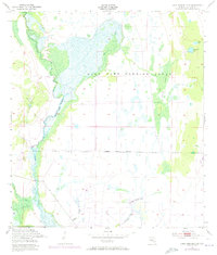
1952 Map of Lake Arbuckle SE
USGS Topo · Published 1973About this map
The Avon Park Bombing Range dominates this landscape in Highlands County, showcasing a mid-century military installation integrated into the native Florida wetlands. The terrain is defined by a complex network of waterways, where Arbuckle Creek meanders along the western boundary and the Avon Park Air Force Base footprint extends into the northern reaches.
Find a feature on this map
12 named features on this map. Tap any name to fly to it.
Don’t see what you’re looking for? This feature index may not catch every label — zoom into the map to look around manually.
Map Details
Editions of this 1952 Lake Arbuckle SE Map
4 editions found
Other maps of this area

1952 · Fort Kissimmee
USGS Topo · 1:24,000

1952 · Lake Arbuckle SW
USGS Topo · 1:24,000

1952 · Fort Kissimmee NW
USGS Topo · 1:24,000

1952 · Lake Arbuckle NE
USGS Topo · 1:24,000

1952 · Lake Arbuckle SE
USGS Topo · 1:24,000

1952 · Lake Arbuckle
USGS Topo · 1:24,000

1952 · Lorida
USGS Topo · 1:24,000

1952 · Sebring
USGS Topo · 1:24,000

1953 · Basinger NW
USGS Topo · 1:24,000

1956 · Fort Pierce
USGS Topo · 1:250,000