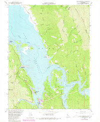
1959 Map of Lake Berryessa
USGS Topo · Published 1980About this map
Lake Berryessa dominates this landscape, its expansive waters filling the former Berryessa Valley. This survey includes underwater contours provided by the U.S. Bureau of Reclamation, showing the submerged course of Putah Creek and its many tributary canyons. Along the western shore, the Monticello Cem sits near Sugarloaf Park, a remnant of the community displaced by the reservoir's creation. The map captures the development of mid-century recreation, with sites like Spanish Flat, Berryessa Marina, and the Steel Canyon Resort established to serve the growing number of visitors. To the east, the terrain rises sharply into the wilderness of Gosling Ridge and Rocky Ridge, where Jackson Peak and Taylor Bluffs mark the boundary between Napa and Yolo counties. Evidence of earlier land use remains in the form of the Gunn Ranch and several oil wells scattered through the canyons.
Find a feature on this map
51 named features on this map. Tap any name to fly to it.
Don’t see what you’re looking for? This feature index may not catch every label — zoom into the map to look around manually.
Map Details
Editions of this 1959 Lake Berryessa Map
4 editions found
Other maps of this area

1902 · Napa
USGS Topo · 1:125,000

1905 · Esparto
USGS Topo · 1:24,000

1916 · Esparto
USGS Topo · 1:31,680

1921 · Mt. Vaca
USGS Topo · 1:62,500

1924 · Capay
USGS Topo · 1:62,500

1942 · Sonoma
USGS Topo · 1:62,500

1942 · Mt. Vaca
USGS Topo · 1:62,500

1942 · St. Helena
USGS Topo · 1:62,500

1943 · Capay
USGS Topo · 1:62,500

1945 · Capay
USGS Topo · 1:62,500
Featured Places
- Steel Canyon Resort, CA
- Spanish Flat, CA
- Berryessa Highlands, CA
- Spanish Flat Resort, CA
- Yolo County, CA