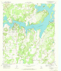
1969 Map of Lake Brownwood
USGS Topo · Published 1972About this map
Lake Brownwood dominates the landscape of north-central Brown County, its jagged shoreline and numerous coves reflecting the topography of the Texas Hill Country. This 1969 field-checked survey highlights the development of lakeside communities like Shamrock Shores and Lake Shore alongside the established Lake Brownwood State Park. The map documents critical water infrastructure, including the Brownwood Dam and the Brownwood Aqueduct, which support the regional economy.
Find a feature on this map
34 named features on this map. Tap any name to fly to it.
Don’t see what you’re looking for? This feature index may not catch every label — zoom into the map to look around manually.
Map Details
Editions of this 1969 Lake Brownwood Map
3 editions found
Other maps of this area

1887 · Coleman
USGS Topo · 1:125,000

1889 · Brownwood
USGS Topo · 1:125,000

1889 · Coleman
USGS Topo · 1:125,000

1894 · Brownwood
USGS Topo · 1:125,000

1924 · Coleman 1-a
USGS Topo · 1:48,000

1924 · Brownwood Reservoir Site
USGS Topo · 1:48,000

1925 · Brownwood 3-b
USGS Topo · 1:48,000

1927 · Grosvenor
USGS Topo · 1:62,500

1928 · Zephyr
USGS Topo · 1:62,500

1950 · Zephyr
USGS Topo · 1:62,500