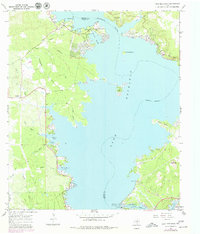
1967 Map of Lake Buchanan
USGS Topo · Published 1979About this map
Lake Buchanan dominates the center of this Texas Hill Country landscape, captured here in the late 1960s with updates from the mid-1970s. The settlement of Bluffton sits on the western shore, positioned near the mouth of Coggins Creek and Redrock Creek. To the south, the massive engineering of Buchanan Dam and its associated Powerhouse manage the flow of the Colorado River into Inks Lake. The map reveals a transition toward recreation and residential development along the shoreline, evidenced by the numerous coves like Wirth Haven Cove and Jeckers Cove, and several public spaces including Black Rock Park and Colorado River Authority Park. Inland, the terrain is marked by seasonal drainages such as Sandy Creek and Pennington Creek, while the Aero-Bee Ranch Landing Strip suggests the early influence of private aviation in this lakeside region.
Find a feature on this map
43 named features on this map. Tap any name to fly to it.
Don’t see what you’re looking for? This feature index may not catch every label — zoom into the map to look around manually.
Map Details
Editions of this 1967 Lake Buchanan Map
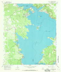
2 editions found
Other maps of this area

1887 · Llano
USGS Topo · 1:125,000

1887 · Burnet
USGS Topo · 1:125,000

1893 · Burnet
USGS Topo · 1:125,000

1894 · Llano
USGS Topo · 1:125,000

1903 · Burnet
USGS Topo · 1:125,000

1904 · Llano
USGS Topo · 1:125,000

1909 · Llano
USGS Topo · 1:125,000

1909 · Burnet
USGS Topo · 1:125,000

1918 · Llano
USGS Topo · 1:125,000

1925 · Burnet 3-b
USGS Topo · 1:48,000