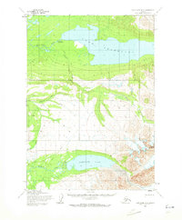
1954 Map of Lake Clark D-3
USGS Topo · Published 1973About this map
Old Village (Abandoned) sits on the northwestern shore of Lake Telaquana, marking a site of former habitation in this remote landscape. The mid-century survey reveals a network of overland transport, specifically the Native Trail which winds through the mountain passes and follows the course of the Telaquana River. To the south, the deep waters of Turquoise Lake are framed by high elevations, including Telaquana Mountain which dominates the southeastern terrain. The drainage patterns are clearly defined, showing the headwaters of the Mulchatna River and the steep descent of Summit Creek. This mapping reflects a period of documentation by the Army Map Service and Geological Survey focused on the topography of the Lake and Peninsula region, capturing the existing indigenous pathways and seasonal sites before modern changes occurred.
Find a feature on this map
10 named features on this map. Tap any name to fly to it.
Don’t see what you’re looking for? This feature index may not catch every label — zoom into the map to look around manually.
Map Details
Editions of this 1954 Lake Clark D-3 Map
2 editions found
Other maps of this area

1946 · Lake Clark
USGS Topo · 1:250,000

1951 · Lake Clark
USGS Topo · 1:250,000

1951 · Lime Hills
USGS Topo · 1:250,000

1954 · Lake Clark C-3
USGS Topo · 1:63,360

1954 · Lake Clark C-4
USGS Topo · 1:63,360

1954 · Lime Hills A-3
USGS Topo · 1:63,360

1954 · Lake Clark D-3
USGS Topo · 1:63,360

1954 · Lime Hills A-4
USGS Topo · 1:63,360

1954 · Lake Clark D-4
USGS Topo · 1:63,360

1958 · Lime Hills A-2
USGS Topo · 1:63,360