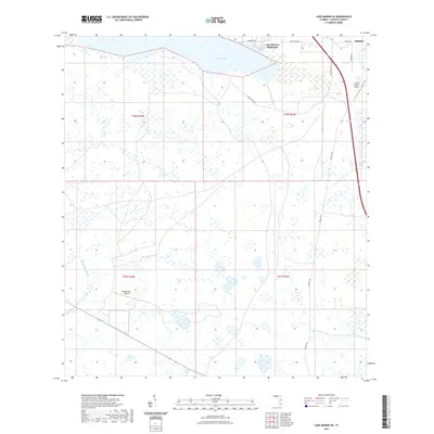
2021 Map of Lake Marian SE
USGS Topo · Published 2021About this map
Lake Marian anchors the northern edge of this Osceola County landscape, where the residential enclave of Lake Marian Highlands sits along the shoreline. Further east, the settlement of Whittier marks the convergence of local transit and commerce at the county line. The terrain is defined by a dense network of wetlands and seasonal drainages, most notably the Blanket Bay Slough which snakes through the southwestern quadrants. This area serves as a hub for light aviation and ranching operations, evidenced by the presence of Flying S Ranch Airport and the remote Blanket Bay Airport. Travel through these marshes and prairies is guided by long stretches of trail and road, including Peavine Trl and Lake Marian Rd, which navigate the rectangular sections of the Florida heartland.
Find a feature on this map
16 named features on this map. Tap any name to fly to it.
Don’t see what you’re looking for? This feature index may not catch every label — zoom into the map to look around manually.
Map Details
Editions of this 2021 Lake Marian SE Map
This is the sole edition of this map. No revisions or reprints were ever made.
Other maps of this area

1952 · Fort Kissimmee NW
USGS Topo · 1:24,000

1953 · Lake Marian NW
USGS Topo · 1:24,000

1953 · Fort Kissimmee NE
USGS Topo · 1:24,000

1953 · Lake Marian SE
USGS Topo · 1:24,000

1953 · Fort Drum NW
USGS Topo · 1:24,000

1953 · Kenansville SW
USGS Topo · 1:24,000

1953 · Lake Marian SW
USGS Topo · 1:24,000

1953 · Kenansville
USGS Topo · 1:24,000

1953 · Lake Marian NE
USGS Topo · 1:24,000

1956 · Fort Pierce
USGS Topo · 1:250,000