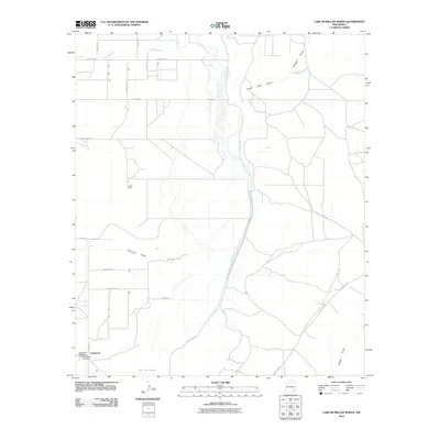
2010 Map of Lake McMillan North
USGS Topo · Published 2010About this map
Lakewood and its surrounding ranchlands are depicted here in the Pecos Valley, just north of the expansive Lake Mc Millan reservoir. The settlement pattern is defined by rural road networks like N Lake Rd and Dayton Rd, which connect isolated homesteads such as the Lewis Ranch to larger regional hubs. The hydrology of the area is particularly complex, showing the confluence of the Rio Peñasco with the Pecos River, alongside numerous ephemeral drainages including Fourmile Draw and Scoggin Draw. For genealogists and local historians, the inclusion of the Old Lakewood Cemetery and the Lakewood Post Office provides specific points of interest for tracing family roots in this part of Eddy County. The landscape is characterized by its semi-arid drainage features and the presence of the Chalk Bluff Spring, illustrating the importance of water sources in the high desert of southeastern New Mexico.
Find a feature on this map
26 named features on this map. Tap any name to fly to it.
Don’t see what you’re looking for? This feature index may not catch every label — zoom into the map to look around manually.
Map Details
Editions of this 2010 Lake McMillan North Map
This is the sole edition of this map. No revisions or reprints were ever made.
Other maps of this area

1943 · Oil City
USGS Topo · 1:62,500

1954 · Seven Rivers
USGS Topo · 1:24,000

1954 · Carlsbad
USGS Topo · 1:250,000

1955 · Artesia
USGS Topo · 1:24,000

1955 · Spring Lake
USGS Topo · 1:24,000

1955 · Dayton
USGS Topo · 1:24,000

1955 · Lake Mc Millan North
USGS Topo · 1:24,000

1955 · Lake Mc Millan South
USGS Topo · 1:24,000

1955 · Red Lake
USGS Topo · 1:24,000

1958 · Carlsbad
USGS Topo · 1:250,000