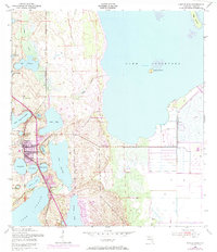
1952 Map of Lake Placid
USGS Topo · Published 1983About this map
Lake Placid serves as the central hub of this Highlands County landscape, dominated by an intricate network of freshwater basins and residential expansion. The town is flanked by numerous water bodies, including Lake Placid to the south and Lake Huntley to the east, while the massive expanse of Lake Istokpoga defines the eastern horizon. Transport and industry in the early 1950s are represented by the Seaboard Coast Line railroad, which cuts north-south through the terrain. The map records the early development of Highlands Park Estates and Sunvale, alongside established local landmarks like Oak Hill Cem. The presence of several smaller lakes, such as Lake Sirena and Lake Pearl, highlights the unique hydrology of this citrus-growing region, where residential plats were beginning to fill the spaces between the water's edge and the rail line.
Find a feature on this map
31 named features on this map. Tap any name to fly to it.
Don’t see what you’re looking for? This feature index may not catch every label — zoom into the map to look around manually.
Map Details
Editions of this 1952 Lake Placid Map
4 editions found
Other maps of this area

1952 · Lake Placid
USGS Topo · 1:24,000

1952 · Lorida
USGS Topo · 1:24,000

1952 · Sebring
USGS Topo · 1:24,000

1953 · Brighton NW
USGS Topo · 1:24,000

1953 · Lake June In Winter
USGS Topo · 1:24,000

1953 · Venus NW
USGS Topo · 1:24,000

1953 · Basinger SW
USGS Topo · 1:24,000

1953 · Basinger NW
USGS Topo · 1:24,000

1953 · Childs
USGS Topo · 1:24,000

1956 · Fort Pierce
USGS Topo · 1:250,000