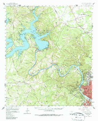
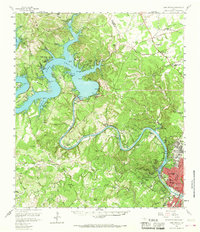
1959 Map of Lake Travis
USGS Topo · Published 1987About this map
Lake Travis and the Colorado River corridor are captured here during a period of significant regional expansion, showing the transition from rural ranching tracts to suburban development. The landscape is defined by the winding waters of Lake Austin and the looming heights of Mount Bonnell and Cat Mountain. To the north, the Jollyville Plateau contains established community markers like the Jollyville Cem and Pond Springs, while the riverbanks feature recreation sites such as Camp Tom Wooten and Lakeland Park. In the city of Austin, the map identifies institutional landmarks including the Texas Confederate Home and the Camp Mabry Military Res. This survey documents the area before the full sprawl of modern suburbs, preserving the locations of many family-named ranches and early rural schools like the Pleasant Valley Sch and Eanes Sch.
Find a feature on this map
135 named features on this map. Tap any name to fly to it.
Don’t see what you’re looking for? This feature index may not catch every label — zoom into the map to look around manually.
Map Details
Editions of this 1959 Lake Travis Map
5 editions found
Other maps of this area

1887 · Blanco
USGS Topo · 1:125,000

1887 · Burnet
USGS Topo · 1:125,000

1893 · Georgetown
USGS Topo · 1:125,000

1893 · Burnet
USGS Topo · 1:125,000

1894 · Blanco
USGS Topo · 1:125,000

1896 · Austin
USGS Topo · 1:125,000

1897 · Austin
USGS Topo · 1:125,000

1903 · Burnet
USGS Topo · 1:125,000

1909 · Burnet
USGS Topo · 1:125,000

1910 · Austin
USGS Topo · 1:125,000