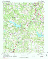
1964 Map of Lake Wheeler
USGS Topo · Published 1984About this map
The transition from the southern suburbs of Raleigh into the rural landscapes of St Marys Township is documented in this 1964 survey, which reveals the intensifying residential development and infrastructure of the era. The southern edge of the capital city features expanding neighborhoods like Twin Lakes Estates, Carolina Pines, and West Parkland, while the Raleigh Airport and the State School for Blind and Deaf occupy prominent positions on the outskirts. This growth contrasts with established rural landmarks such as Yates Millpond and its associated Yates Mill, alongside the massive reservoir of Lake Wheeler.
Find a feature on this map
80 named features on this map. Tap any name to fly to it.
Don’t see what you’re looking for? This feature index may not catch every label — zoom into the map to look around manually.
Map Details
Editions of this 1964 Lake Wheeler Map
5 editions found
Other maps of this area

1943 · Durham South
USGS Topo · 1:62,500

1943 · Raleigh
USGS Topo · 1:62,500

1951 · Raleigh
USGS Topo · 1:62,500

1951 · Durham South
USGS Topo · 1:62,500

1953 · Raleigh
USGS Topo · 1:250,000

1954 · Raleigh
USGS Topo · 1:250,000

1964 · Lake Wheeler
USGS Topo · 1:24,000

1964 · Garner
USGS Topo · 1:24,000

1964 · Angier
USGS Topo · 1:24,000

1964 · Edmondson
USGS Topo · 1:24,000