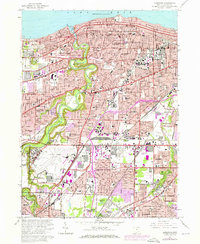
1963 Map of Lakewood
USGS Topo · Published 1971About this map
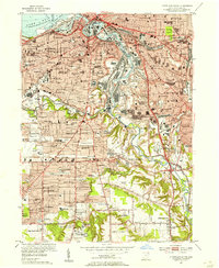
Lake Erie defines the northern reaches of this dense suburban corridor, where the steep banks of the Rocky River create a winding green break through the grid of Lakewood and Rocky River. The map illustrates the intensive development of Greater Cleveland in the early 1970s, as highlighted by purple urban expansion over the original 1963 survey. This era shows the massive footprint of the Cleveland Hopkins Airport and industrial sites like the Cleveland Ordnance Plant coexisting with established neighborhoods. Higher ground is marked by North Ridge and Center Ridge, ancient shoreline features that now carry major thoroughfares. The landscape is dotted with numerous parochial institutions like St Augustines Academy and Nazareth Academy, alongside expansive greenspaces such as the Rocky River Reservation and the large Holy Cross Cemetery.
Find a feature on this map
154 named features on this map. Tap any name to fly to it.
Don’t see what you’re looking for? This feature index may not catch every label — zoom into the map to look around manually.
Map Details
Editions of this 1963 Lakewood Map
4 editions found
Other maps of this area

1901 · Euclid
USGS Topo · 1:62,500

1902 · Berea
USGS Topo · 1:62,500

1903 · Cleveland
USGS Topo · 1:62,500

1903 · Euclid
USGS Topo · 1:62,500

1904 · Berea
USGS Topo · 1:62,500

1950 · Cleveland
USGS Topo · 1:250,000

1953 · West View
USGS Topo · 1:24,000

1953 · Broadview Heights
USGS Topo · 1:24,000

1953 · Berea
USGS Topo · 1:24,000
1953 · Cleveland South
USGS Topo · 1:24,000