
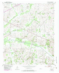
1952 Map of Lambert
USGS Topo · Published 1952About this map
The Loosahatchie River and its accompanying Loosahatchie Canal dominate this 1952 topographic study of Fayette County, revealing a landscape defined by significant hydrologic engineering. Broad floodplains like Loosahatchie Bottom and Cypress Bottom are marked by an intricate network of drainage canals designed to manage the West Tennessee wetlands for agricultural use.
Find a feature on this map
37 named features on this map. Tap any name to fly to it.
Don’t see what you’re looking for? This feature index may not catch every label — zoom into the map to look around manually.
Map Details
Editions of this 1952 Lambert Map
2 editions found
Other maps of this area

1943 · Collierville
USGS Topo · 1:62,500

1949 · Moscow
USGS Topo · 1:62,500

1952 · Stanton
USGS Topo · 1:24,000

1952 · Dancyville
USGS Topo · 1:24,000

1952 · Laconia
USGS Topo · 1:24,000

1952 · Stanton
USGS Topo · 1:62,500

1953 · Collierville
USGS Topo · 1:50,000

1954 · Mason
USGS Topo · 1:62,500

1956 · Blytheville
USGS Topo · 1:250,000

1959 · Blytheville
USGS Topo · 1:250,000