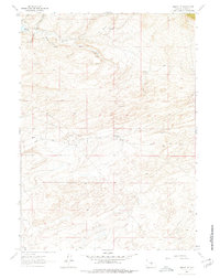
1961 Map of Lamont NE
USGS Topo · Published 1978About this map
Mahoney Dome Oil Field defines the industrial footprint of this high desert region in Carbon County during the early 1960s. The landscape is a network of energy infrastructure and isolated outposts, evidenced by the presence of Ohio Camp and several prominent pipelines that traverse the terrain. Settlement is sparse, limited to sites like the Dorr Place tucked near Dorr Meadow, suggesting a history tied to seasonal ranching or resource extraction.
Find a feature on this map
18 named features on this map. Tap any name to fly to it.
Don’t see what you’re looking for? This feature index may not catch every label — zoom into the map to look around manually.
Map Details
Editions of this 1961 Lamont NE Map
3 editions found
Other maps of this area

1953 · Ferris
USGS Topo · 1:24,000

1953 · Spanish Mine
USGS Topo · 1:24,000

1953 · Riddle Cut
USGS Topo · 1:24,000

1955 · Casper
USGS Topo · 1:250,000

1958 · Casper
USGS Topo · 1:250,000

1960 · Separation Rim
USGS Topo · 1:24,000

1960 · Boggy Meadows
USGS Topo · 1:24,000

1961 · Lamont NE
USGS Topo · 1:24,000

1961 · Lamont
USGS Topo · 1:24,000

1962 · Casper
USGS Topo · 1:250,000