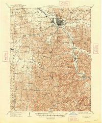
1909 Map of Lancaster
USGS Topo · Published 1948About this map
Lancaster serves as the hub of this early 20th-century landscape, where industrial growth and traditional rural infrastructure intersect along the Hocking River. The city is a terminal point for several rail lines, including the Wheeling and Muskingum Valley RR and the Columbus and Valley Electric RR, reflecting the era's transition from water to rail transport. Traces of the Abandoned Hocking Canal are still visible southeast of the city, running parallel to the river toward Sugar Grove.
Find a feature on this map
76 named features on this map. Tap any name to fly to it.
Don’t see what you’re looking for? This feature index may not catch every label — zoom into the map to look around manually.
Map Details
Editions of this 1909 Lancaster Map
2 editions found
Other maps of this area

1904 · Zaleski
USGS Topo · 1:62,500

1906 · Chillicothe
USGS Topo · 1:62,500

1907 · Zaleski
USGS Topo · 1:62,500

1907 · Logan
USGS Topo · 1:62,500

1907 · Lancaster
USGS Topo · 1:62,500

1907 · Thurston
USGS Topo · 1:62,500

1908 · Chillicothe
USGS Topo · 1:62,500

1909 · Thornville
USGS Topo · 1:62,500

1909 · Lancaster
USGS Topo · 1:62,500

1909 · Logan
USGS Topo · 1:62,500