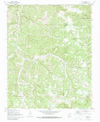
1972 Map of Landis
USGS Topo · Published 1988About this map
Landis and the surrounding Ozark Highlands are documented here as they appeared in the early 1970s, characterized by isolated family settlements and mountain-top cemeteries. The terrain is deeply carved by water, with Turkey Creek and Big Creek flowing through complex hollows like Wildcat Hollow and Young Hollow. Genealogical interest is particularly high on this sheet, which records several family-named burial grounds including Landis Cem, Passmore Cem, and Scribner Cem.
Find a feature on this map
32 named features on this map. Tap any name to fly to it.
Don’t see what you’re looking for? This feature index may not catch every label — zoom into the map to look around manually.
Map Details
Editions of this 1972 Landis Map
2 editions found
Other maps of this area

1890 · Mountain Home
USGS Topo · 1:125,000

1891 · Mountain Home
USGS Topo · 1:125,000

1892 · Marshall
USGS Topo · 1:125,000

1892 · Mountain View
USGS Topo · 1:125,000

1893 · Yellville
USGS Topo · 1:125,000

1894 · Mountain View
USGS Topo · 1:125,000

1894 · Mountain Home
USGS Topo · 1:125,000

1894 · Marshall
USGS Topo · 1:125,000

1901 · Marshall
USGS Topo · 1:125,000

1903 · Yellville
USGS Topo · 1:125,000