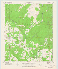
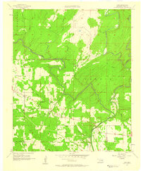
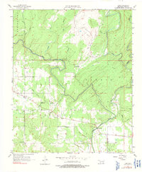
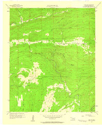
1957 Map of Lane
USGS Topo · Published 1975About this map
Lane serves as the primary settlement on this landscape, which is defined by the winding course of Muddy Boggy Creek and its complex network of tributaries. The map reveals a rural community supported by local institutions, including the Butler Sch and Iron Stob Ch. A sharp meander in the creek is identified as Negro Bend, just north of where the North Branch and South Branch of Double Springs Creek converge. The prevalence of named water bodies like Potapo Creek and McGee Creek suggests a terrain shaped by the local watershed, while the presence of Oil Wells and a Gaging Station points to the early natural resource management and industrial activity in Atoka County during the mid-1950s. Genealogists may find value in the specific locations of Butler Cem and other marked burial sites scattered across the township lines.
Find a feature on this map
28 named features on this map. Tap any name to fly to it.
Don’t see what you’re looking for? This feature index may not catch every label — zoom into the map to look around manually.
Map Details
Editions of this 1957 Lane Map
3 editions found
Other maps of this area

1899 · Atoka
USGS Topo · 1:125,000

1900 · Atoka
USGS Topo · 1:125,000

1901 · Antlers
USGS Topo · 1:125,000

1912 · Antlers
USGS Topo · 1:125,000

1925 · Antlers
USGS Topo · 1:125,000

1950 · Mcalester
USGS Topo · 1:250,000
1956 · Stringtown
USGS Topo · 1:24,000
1957 · Lane NW
USGS Topo · 1:24,000
1957 · Farris
USGS Topo · 1:24,000
1957 · Bruno
USGS Topo · 1:24,000