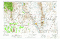
1955 Map of Las Cruces
USGS Topo · Published 1974About this map
Las Cruces and the Mesilla Valley form the central axis of this mid-century New Mexican landscape, where the Rio Grande provides a lifeline through the desert. The map captures a period of significant military and scientific expansion, notably showing the White Sands Missile Range and the NASA Antenna Test Facility established in the arid basins. To the west, Deming serves as a major hub at the junction of the Southern Pacific railroad and U S Highway 80. The terrain is defined by dramatic volcanic and tectonic features, from the jagged Organ Mountains to the distinct Aden Crater and The Malpais. Local history is preserved in the placement of small agricultural and railway settlements like Salem, Rincon, and Mesquite, along with recreational sites such as Rock Hound State Park and Caballo Lake State Park.
Find a feature on this map
103 named features on this map. Tap any name to fly to it.
Don’t see what you’re looking for? This feature index may not catch every label — zoom into the map to look around manually.
Map Details
Editions of this 1955 Las Cruces Map
3 editions found

Other maps of this area

1891 · Las Cruces
USGS Topo · 1:125,000

1893 · Las Cruces
USGS Topo · 1:125,000

1896 · El Paso
USGS Topo · 1:125,000

1899 · Deming
USGS Topo · 1:125,000

1903 · Cerro Alto
USGS Topo · 1:125,000

1908 · El Paso
USGS Topo · 1:125,000

1909 · Silver City
USGS Topo · 1:125,000

1911 · Alum Mountain
USGS Topo · 1:125,000

1913 · Alum Mountain
USGS Topo · 1:125,000

1915 · Deming
USGS Topo · 1:125,000