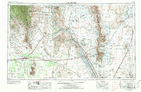
1955 Map of Las Cruces
USGS Topo · Published 1974About this map
The Rio Grande valley serves as the central artery for this 1955 survey, anchoring the agricultural and academic hub of Las Cruces. This era captures a landscape undergoing a profound shift from traditional ranching and river commerce to a high-technology military and aerospace corridor. The presence of New Mexico State College and the sprawling White Sands Missile Range indicates the region's mid-century role in defense research. Beyond the river bottoms, the terrain transitions sharply into the volcanic features of Aden Crater and the stark white gypsum of the White Sands National Monument. Transportation networks like the Atchison Topeka and Santa Fe and the Southern Pacific railroads crisscross the desert, connecting older settlements like Deming and Hatch to the burgeoning military facilities at Fort Bliss Military Reservation.
Find a feature on this map
170 named features on this map. Tap any name to fly to it.
Don’t see what you’re looking for? This feature index may not catch every label — zoom into the map to look around manually.
Map Details
Editions of this 1955 Las Cruces Map
3 editions found

Other maps of this area

1891 · Las Cruces
USGS Topo · 1:125,000

1893 · Las Cruces
USGS Topo · 1:125,000

1896 · El Paso
USGS Topo · 1:125,000

1899 · Deming
USGS Topo · 1:125,000

1903 · Cerro Alto
USGS Topo · 1:125,000

1908 · El Paso
USGS Topo · 1:125,000

1909 · Silver City
USGS Topo · 1:125,000

1911 · Alum Mountain
USGS Topo · 1:125,000

1913 · Alum Mountain
USGS Topo · 1:125,000

1915 · Deming
USGS Topo · 1:125,000