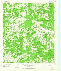
1962 Map of Latex
USGS Topo · Published 1964About this map
The Texas Louisiana borderland, specifically where Harrison County meets Caddo Parish, is defined by a dense network of resource extraction and rural community hubs. The settlement of Latex sits at a geographic crossroads near the Louisiana and Arkansas boundary, surrounded by numerous oil wells and gas wells that underscore the industrial character of the mid-century landscape. This extraction economy exists alongside long-established local institutions, including the Jonesville School and several rural congregations such as Pleasant Hill Church and Shiloh Church.
Find a feature on this map
29 named features on this map. Tap any name to fly to it.
Don’t see what you’re looking for? This feature index may not catch every label — zoom into the map to look around manually.
Map Details
Editions of this 1962 Latex Map
Other maps of this area

1943 · Waskom
USGS Topo · 1:62,500

1944 · Caddo Lake
USGS Topo · 1:62,500

1945 · Waskom
USGS Topo · 1:62,500

1945 · Greenwood
USGS Topo · 1:62,500

1946 · Caddo Lake
USGS Topo · 1:62,500

1948 · Mooringsport
USGS Topo · 1:62,500

1955 · Shreveport
USGS Topo · 1:250,000

1955 · Mooringsport
USGS Topo · 1:62,500

1955 · Greenwood
USGS Topo · 1:62,500

1956 · Shreveport
USGS Topo · 1:250,000