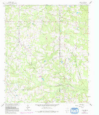
1962 Map of Latex
USGS Topo · Published 1991About this map
Latex stands at the intersection of the Texas, Louisiana, and Arkansas borders, serving as a focal point for a landscape defined by state boundaries and riparian systems. The 1960s terrain is characterized by a high density of rural infrastructure, including numerous Oil Wells and a network of pipelines that reflect the region's mid-century energy industry. Settlement patterns follow the creeks and bayous, with Watson Bayou in the north and Bullard Creek winding through the center.
Find a feature on this map
31 named features on this map. Tap any name to fly to it.
Don’t see what you’re looking for? This feature index may not catch every label — zoom into the map to look around manually.
Map Details
Editions of this 1962 Latex Map
Other maps of this area

1943 · Waskom
USGS Topo · 1:62,500

1944 · Caddo Lake
USGS Topo · 1:62,500

1945 · Waskom
USGS Topo · 1:62,500

1945 · Greenwood
USGS Topo · 1:62,500

1946 · Caddo Lake
USGS Topo · 1:62,500

1948 · Mooringsport
USGS Topo · 1:62,500

1955 · Shreveport
USGS Topo · 1:250,000

1955 · Mooringsport
USGS Topo · 1:62,500

1955 · Greenwood
USGS Topo · 1:62,500

1956 · Shreveport
USGS Topo · 1:250,000